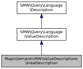
Inheritance diagram for Maps\SemanticMW\ValueDescriptions\AreaDescription:

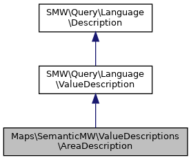
Collaboration diagram for Maps\SemanticMW\ValueDescriptions\AreaDescription:

Public Member Functions | |
| __construct (SMWDataItem $areaCenter, int $comparator, string $radius, DIProperty $property=null) | |
| prune (&$maxsize, &$maxdepth, &$log) | |
| getQueryString ( $asValue=false) | |
| getSQLCondition ( $tableName, array $fieldNames, IDatabase $db) | |
| getBoundingBox () | |
 Public Member Functions inherited from SMW\Query\Language\ValueDescription Public Member Functions inherited from SMW\Query\Language\ValueDescription | |
| __construct (DataItem $dataItem, DIProperty $property=null, $comparator=SMW_CMP_EQ) | |
| getFingerprint () | |
| getDataValue () | |
| getDataItem () | |
| getProperty () | |
| getComparator () | |
| getQueryString ( $asValue=false) | |
| isSingleton () | |
| getSize () | |
 Public Member Functions inherited from SMW\Query\Language\Description Public Member Functions inherited from SMW\Query\Language\Description | |
| getPrintRequests () | |
| setPrintRequests (array $printRequests) | |
| addPrintRequest (PrintRequest $printRequest) | |
| prependPrintRequest (PrintRequest $printRequest) | |
| getFingerprint () | |
| getMembership () | |
| setMembership ( $membership) | |
| getQueryString ( $asValue=false) | |
| isSingleton () | |
| getSize () | |
| getDepth () | |
| getQueryFeatures () | |
| prune (&$maxsize, &$maxDepth, &$log) | |
| __toString () | |
Additional Inherited Members | |
 Protected Attributes inherited from SMW\Query\Language\Description Protected Attributes inherited from SMW\Query\Language\Description | |
| $m_printreqs = [] | |
| $fingerprint = null | |
Detailed Description
Description of a geographical area defined by a coordinates set and a distance to the bounds. The bounds are a 'rectangle' (but bend due to the earths curvature), as the resulting query would otherwise be to resource intensive.
GNU GPL v2+
Member Function Documentation
◆ getBoundingBox()
| Maps\SemanticMW\ValueDescriptions\AreaDescription::getBoundingBox | ( | ) |
- Returns
- float[] An associative array containing the limits with keys north, east, south and west.
◆ getSQLCondition()
| Maps\SemanticMW\ValueDescriptions\AreaDescription::getSQLCondition | ( | $tableName, | |
| array | $fieldNames, | ||
| IDatabase | $db | ||
| ) |
- See also
- SomePropertyInterpreter::mapValueDescription
FIXME: store specific code should be in the store component
- Parameters
-
string $tableName string[] $fieldNames IDatabase $db
- Returns
- string|false
◆ prune()
| Maps\SemanticMW\ValueDescriptions\AreaDescription::prune | ( | & | $maxsize, |
| & | $maxdepth, | ||
| & | $log | ||
| ) |
- See also
- Description::prune
The documentation for this class was generated from the following file:
- AreaDescription.php
 1.8.13